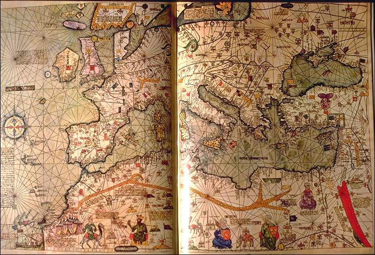
Vallás – tér – kép. A középkori térkép mint a világkép vetülete
DOI:
https://doi.org/10.15170/PONTES.2018.01.01.04Kulcsszavak:
Vallás, térkép, világkép, középkorAbsztrakt
Th e present paper analyses the fundamental diff erences between the concept and use of current and medieval maps. Th e latter had diff erent functions determined by the physical context, i. e. by the frame of their making and the world view, namely the religious background. Aft er a short survey of terminology applied to describe the ’map’ in the middle ages, the paper analyses the main features of the maps as well as the essential periods of map-making. Then, it examines the correlation of the content, the forms and the functions to answer the main question whether medieval cartography really stands out in sharp contrast to ancient and early modern map-making, and how the medieval worldview, especially the Christian faith, infl uenced the realization of mappemundi.
Hivatkozások
Chisholm 1911 = Chisholm, Hugh: Pegolotti, Francesco Balducci. Encyclopeaedia Britannica. Vol. 21. London, 1911. 57–58.
Crone 1965 = Crone, Gerald R.: New Light on The Hereford Map. The Geographical Journal 131. (1965), 447–458.
De Looze 2016 = De Looze, Laurence: The Letter and the Cosmos. How the Alphabet Has Shaped the Western View of the World. Toronto–Buffalo–London, 2016.
Destombes, Marcel (éd.): Mappemondes A.D. 1200–1500. Catalogue préparé par la Comission des Cartes Anciennes de l’Union Géographique Internationale. Amsterdam, 1964.
Evans 1936 = Evans, Allan (ed.): Francesco Balducci Pegolotti. La pratica della mercatura. Cambridge Massachusetts, 1936. (Medieval Academy Books 29: http://
c.ymcdn.com/sites/www.medievalacademy.org/resource/resmgr/maa_books_online/evans_0024_bkmrkdpdf.pdf – Letöltés: 2018. március 2.)
Harvey 1996 = Harvey, Paul Dean Adshead: Mappa Mundi. The Hereford Word Map. London, 1996.
Levi – Levi 1967= Levi, Annalina – Levi, Mario. Itineraria picta: Contributo allo studio della Tabula Peutingeriana. Roma, 1967.
Loughlin 1907 = Loughlin, James: Antipodes. In: The Catholic Encyclopedia I. New York, 1907. (http://www.newadvent.org/cathen/01581a.htm – letöltés: 2018. március 2.)
MKL (’kánon kép’) = ’Kánon kép’. In: Magyar Katolikus Lexikon (online kiadás: http://lexikon.katolikus.hu/K/k%C3%A1non-k%C3%A9p.html – Letöltés: 2018. március 2.)
MKL (’Sacramentarium’) = ’Sacramentarium’. In: Magyar Katolikus Lexikon (online kiadás: http://lexikon.katolikus.hu/S/sacramentarium.html – Letöltés: 2018. március 2.)
Rosien 1952 = Rosien, Walter: Die Ebstorfer Weltkarte. Hannover. 1952. (Veröffentlichungen des Niedersächsischen Amtes für Landesplanung und Statistik, Neue Folge, 19, Reihe A II) Vielliard 1938 = Vielliard, Jeanne: Le Guide du Pèlerin de Saint-Jacques de Compostelle, texte latin du XIIe siècle, édité et traduit en français d’après les manuscrits de Compostelle et de Ripoll. Mâcon, 1938.
Woodward 1987 = Woodward, David: Medieval Mappaemundi. In: Harley, J.B. – Woodward, D. (ed.): The History of Cartography. vol. 1. (Cartography in Prehistoric, Ancient and Medieval Europe and the Mediterranean) Chicago–London, 1987. 283–367. (http://www.press.uchicago.edu/books/HOC/HOC_V1/HOC_VOLUME1_chapter18.pdf – Letöltés: 2018. március 2.)
##submission.downloads##
Megjelent
Folyóirat szám
Rovat
License
Copyright (c) 2018 PONTES

This work is licensed under a Creative Commons Attribution-NonCommercial-NoDerivatives 4.0 International License.